Your guide to UK harbours, with guides and navigation information
Welcome aboard visitMyHarbour
visitMyHarbour is your go‑to online guide for sailors, cruisers, and anyone who loves life on the water. Whether you’re planning a coastal passage, researching a new marina, or brushing up on navigation skills, we bring everything you need together in one reliable place.
Explore harbours and marinas across the UK and Ireland
Our detailed harbour guides include sailing directions, mooring options, facilities, local knowledge, and up‑to‑date visitor information, helping you plan every stop with confidence.
Access digital charts and navigation tools
Members can use our seamless digital charts, tidal data, and practical planning tools to prepare safe, efficient routes before heading out.
Plan smarter, sail safer, enjoy your travels
From trip planning to real‑time checks, visitMyHarbour helps you make informed decisions on the water, so you spend less time searching and more time sailing.
⚓ Remember to follow us on Facebook, Instagram and YouTube for the latest updates coming to the website, and explore our new membership options to make sure you get the very best from visitMyHarbour.
Research your next destination
Explore harbours, marinas, creeks and inlets across the UK and Ireland. Every location comes with full sailing directions, detailed charts, and photo galleries to help you get a true feel for the approach.
You’ll find all mooring options clearly laid out, from prices and local facilities to provisioning spots, launch sites, pubs and dining ashore. It’s impartial, original, sailor‑written information designed to help you plan with confidence.
And best of all, it’s free to use!
Plan your next passage...
Once you’ve researched your possible stops and destinations, it’s time to start shaping the passage itself.
Check dates, tides, currents, fuel stops and local contacts,everything you need is right here for members, including our unique passage‑planning tool.
Now, using our “For Navigation” charts, you can prepare routes and waypoints from the comfort of home. Plot your course, refine your options, and head out knowing your passage is planned with confidence.
Know the tide before you cast off...
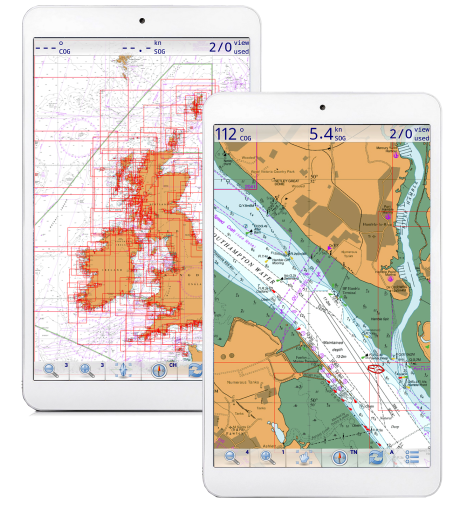
Navigate in real-time at sea
Use our “buy and keep” chart packs (UK and international) running on selected GPS navigation apps for your tablet, phone or laptop. Follow your planned routes, adjust your course on the move, and stay fully aware of your surroundings.
Our charts work with a wide range of supported programs, including navigation, AIS, simulation, and even weather and tide routing. You choose the software that suits your sailing style, including popular options such as OpenCPN.
Your practical guide to harbours and marinas
Every harbour comes with full sailing directions, free charts, and photo galleries to help you visualise the approach before you cast off. You’ll find all mooring options clearly detailed, including prices, local facilities, provisioning spots, launching places, and the best pubs and dining ashore.
Stay fully prepared with 7‑day weather forecasts and tide tables, giving you the conditions you need for confident planning.
⚓ Logged‑in visitors can share comments, updates, and local knowledge, helping fellow sailors stay informed and making every harbour guide richer for the whole cruising community.
Our Harbours
Passage planning: what every skipper must prepare
Before going to sea, every skipper must gather the navigational information needed for a safe and compliant passage plan. UK law requires a written passage plan for every voyage, from short leisure sails to commercial passages.
A complete passage plan must describe the voyage from dock to dock, including:
Departure pilotage: leaving your mooring and navigating out of the harbour.
Main passage: the coastal or offshore leg, including tides, currents, hazards, fuel stops and communications.
Arrival pilotage: the approach, entrance and docking at your destination port.
These requirements follow SOLAS (International Convention for the Safety of Life at Sea), which mandates that a passage plan must be prepared even for short leisure trips. The plan must be written down, not just plotted digitally, relying solely on software can lead to errors and navigational accidents.
⚓ A well‑prepared passage plan keeps you safe, compliant, and confident at sea.
Why full membership to visitMyHarbour pays off
Unlock full passage‑planning power This is where full membership of VisitMyHarbour truly comes into its own. Everything you need to prepare a proper, compliant passage plan for UK and Ireland waters is gathered right here. A one‑stop planning hub designed for sailors who want to get it right before they cast off.
With full membership, you can prepare your written passage plans using a vast collection of tidal data, chart information, and planning resources in the members’ area. Combine this with our extensive harbour coverage in the free section of the site to build detailed pilotage plans, sketch approaches, note buoyage and light signatures, and map out safe entry and exit routes.
Our unique Google Earth – VisiCharts overlay lets you draw your intended sea passage directly on the latest satellite/chart imagery. Make notes on tidal gateways, timings, hazards, and approaches. Extract Lat/Lngs. Build your plan with clarity and confidence, all from the comfort of home, on a big screen, with every tool you need at your fingertips.
🌊 Join Over 9,000 Members
Become a VisitMyHarbour member If you enjoy what you see on this website, you’ll love what full membership unlocks. Join more than 9,000 paid members, including some very well‑known sailing names.
For just £18.95 per year, you get:
Full access to our members’ research tools and planning resources
Seamless zoomable 2026 Satellite/Chart overlays
Downloadable PDF harbour coverage for offline use
A huge library of charts and tidal data
It’s exceptional value and a powerful upgrade for any sailor who wants to plan smarter, sail safer, and explore with confidence.
Navigation
 Made your plans? Now plot your routes with ease in one of our GPS chartplotting systems
Use one of our supported GPS chartplotting systems to prepare your passage on beautiful raster charts. It's the perfect complement to the vector charts in your marine plotter. Our chart packs are buy‑and‑keep (download or USB), with no subscription and no ongoing fees.
We focus on making high‑quality charts available for the navigation software you already use, running on the phones, tablets and laptops you already own.
What boaters are saying...
The website Visit My Harbour is a great tool to plan navigations, check harbours, tides, raster charts, etc. The people behind the scene have always been helpful, answering rapidly and personnally to any questions.
They play a big part in my navigations, and the use of Marine Navigator combined with the VMH charts turning Android devices into real time chart plotters are a a tool I will always consider as the best digital navigation aid on board.