Planning on sailing out of your "comfort zone" ? Interested in doing a bit of passage planning ?
You probably ALREADY OWN the most powerful chart plotting equipment you can buy
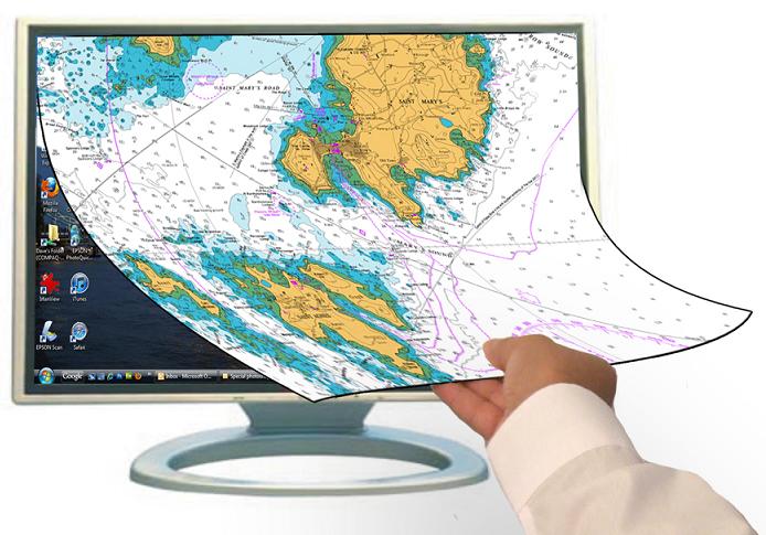
Try out passage planning, chart-plotting or maybe just browsing and dreaming, on a BIG SCREEN. At home. At work. Or actually navigating on your boat. You won't go back...
You'll be using the latest charts at all available scales and you can make A4 prints
Is power consumption an issue for you when navigating onboard?
 Instead of using a Windows laptop...
You could swap to an Android tablet when on-board. Decent Android tablets use very little power, have built in GPS, and start almost instantly.
Using exactly the same charts.
Using routes you've planned on the big screen Windows plotter if reqiured, or prepare routes on the tablet.
Up to 4 Android activations allowed (Needs "Marine Navigator" app from the PlayStore, costs about £5.50)
It does what it says on the tin:
"Charts for SeaClear UK/Ireland" (on a DVD) is an incredibly versatile piece of kit. It can transform equipment you probably already own into powerful planning and NAVIGATING tools. Just what you need when out there in the shipping lanes... or negotiating a foggy estuary.
This is the most popular "For Nav" product we've ever made... There's over 1392 of these DVD chart packages out there already and growing monthly.
(Or £20 for members) HERE
This package contains over 800 UK/Ireland charts at all scales from harbour plan to overview. Channel Islands to the Shetlands. Atlantic coasts of Ireland to the North Sea. All pre-loaded into the easy to use SeaClear navigation software.
PLUS the same charts in Android compatible format, ready for you to install on up to 4 tablets/phones
Quick Summary
- Full coverage UK/Irish waters 800+ Chart/lets all PRELOADED
- Tried and tested SeaClear navigation software included and set up
- Android installation ability built in. License allows up to 4 Android installations in addition to Windows use.
- Charts are licensed "For Navigation", issued 1st July 2013
- All on one Windows compatible DVD
- Portable, install on multiple Windows machines
- DVD acts as "ignition key", spins ONCE on start up, then stops.
- Superfast, average new chart loading time 1 second
- GPS compatible Compatible GPS for SeaClear
- AIS compatible (not Android) Get an AIS receiver to go with SeaClear
- Fully expandable to other areas, Med, US, West Indies etc.
- No updating, just replace package (at discount) to get new charts.
- Free 2013/2014 Tide-Tables for Windows installations.
- 30 day "No Quibble" money back guarantee.
Windows The downside of all normal installed packages is they are locked to a single machine, thus not truly portable. Our SeaClear packages can be installed on multiple machines, at home, on board, at work. Lightning fast too. Our unique system uses the DVD/USB as a "licensing key". It needs to be present to start up our package, but then can even be taken out. For Windows: System Requirements: SeaClear is a lightweight application, and will run quickly with no fuss in older computers. DVD VERSION: Windows XP , Vista, Windows 7, Windows 8 DVD drive needed, disc acts as "ignition key". Note: This package can be installed on multiple machines, DVD acts as a key. USB ports required to connect GPS and/or AIS if needed. Mouse recommended for ease of use. Full telephone support for buyers.
TIP: Try plugging your windows computer into a BIG SCREEN for passage planning at home.
Android installation is via USB cable from your PC to the Android tablet, charts are transferred to "Marine Navigator", the Android app. There is a registration proceedure and package is locked to the Android device. Will install on Android 2.2 upwards. Needs "Marine Navigator" app by Ronald Koenig, about £5.50 from the PlayStore.
Buy NOW IN STOCK FOR DESPATCH TODAY
"Charts for SeaClear UK/Ireland 2013 Edition". As with all physical products we make and sell, there is a 30 day no quibble money back guarantee, try this at home risk free. Please note a DVD drive is needed to use this package on a Windows machine (not reqd. for Android). Use the box below to buy the DVD- You won't get newer charts anywhere.
DVD Price £29.50 plus 1.95/2.95 postage UK/EU. Price in box is the grand total payable
Charts are fully licensed FOR NAVIGATION
No DVD drive on your Windows machine ?
Other options available, buy on encrypted USB dongle CLICK HERE
The dongle offers all the features of the DVD, inc Tide Tables, up to 4 Android installations, portability, etc. BUT: No DVD drive needed, and ONE FREE CONTENT UPDATE 7-11 months after purchase
For PC/laptop use there is NO difference in speed between the dongle and the DVD, so if your laptop has a DVD drive we recommend the DVD. Don't forget the DVD only spins once when the package is started to verify it... after that you can remove it. (likewise with the dongle)
Remember, here at VisitMyHarbour we have been vetted and are "Approved by Trading Standards" We've earned that "Buy with Confidence" logo. If you can't get on with what you've bought, just send it back for a no quibble refund. You can't really loose.
Want some tech help ? Advice ? You'll get someone with real seagoing experience, who know what they are talking about, and above all ENJOYS talking to you....
Questions ? 01983 567866 M-F 10-6 Sat 10-1.30 We're easy to get hold of.
OK, what is this all about ? What can I do with this DVD package ?
So, you have a boat and you get out to sea a bit ? You normally stick close to base but sometimes you move further afield, away from your "comfort zone". Perhaps you just dream of passage making around our coastline. Maybe you trailer sail to new destinations during the summer. Possibly you've got some RYA qualifications and plan to charter a boat in the UK ?
Or maybe you'd just like to see what's involved in a passage on a boat that probably only travels at 5Knts. Distances involved. Time at sea. How many night pasages.
The DVD (or USB) gives you the ability to turn a Windows PC or Laptop with DVD drive into a fantastic planning tool. Plan and measure routes, drop waypoints.. dream that cruise in the comfort of your home on a big screen. In conjunction with some online research (such as the vast trove of harbour and tidal information provided freely on this website)... You will have the basis for a passage plan.
With a printer you can amass and collate all the harbour and tidal info you'll need from this website. The "at sea" passage routes (and alternative plans in case of adverse weather), can all be saved within the SeaClear software. Ready for use at sea. You can even print off A4 chartlets by screen-shotting from within SeaClear.
Your passage plans can cross multiple charts at all scales. Make rough plans on a medium scale chart. Then amend them after examining your track line on the largest scale charts available. It's easy to do using a mouse (we recommend a mouse as opposed to a laptops touch pad).
So you'd have a combination of printed informational material, and a series of passage routes made in SeaClear using the built in charts.
Right.. now to sea. A few options availabe here. If you have a marine GPS on the boat that you can connect with a cable to your Windows machine (supplied by the GPS manufacturer, normally with driver software).. you could:
Transfer your routes to the onboard marine GPS. You can either type in the lat/longs of the waypoints you've prepared in SeaClear. Or (with a bit of initial setting up, works with Garmin and Magellan GPS sets) you can send whole route(s) to the marine GPS. You then use the marine GPS to follow your routes. OK, no quick visual reference of the position on a chart, but not much power consumption.
Android use on-board
The ideal power saving solution. This involves getting yourself an Android tablet with built in GPS. Prices ranges from about £90 to £250. 7" tablets are OK, bit fiddly for routes and waypoint creation. 10" tablets are best for this use, but harder to slip into an inside pocket. You get Marine Navigator app from the playstore for about £5.50 (allows multiple installations). You install our charts and activate. You can transfer routes made on the SeaClear windows program (Big Screen) TO the small screen Android tablet (look out for a "how to" article coming on this subject... it's easy enough). OR you can make the routes directly on the Android device. They use exactly the same charts as the SeaClear Windows version. The Android tablets use very little power, can be charged on-board with an adapter, and turn on almost instantly. If protected from wet, they are ideal chartplotters. They are not AIS compatible.
Android tablet in bracket
"The stars of the show were the oldish Aurohelm 200 tiller pilot and Nexus 7 tablet (free with my phone) with a £4.50 app and admiralty charts from Visitmyharbour.com covering the whole of the UK, simply superb, never missed a beat which is more than can be said for the Garmin which has developed back lighting and contrast issues" Cardiff to E.Coast
Windows use on-board
 Using the Windows laptop as your on-board chartplotter: If you want to use your Windows laptop as the chartplotter (and can afford the power... they generally draw 2-3 amps at 12v)... Then you can use a GPS to show your position on the charts in SeaClear. Follow your pre-prepared routes. Quickly make adjustments for prevailing weather/tidal conditions. See where you are on the charts at all times. To use SeaClear in this manner you don't need a marine GPS connected, just a cheap compatible USB GPS. We supply a bluetooth GPS kit that's ideal for this at £26.50. AIS with an AIS receiver connected you can see the shipping around you. This is a great safety feature in poor visibility, at night and around shipping lanes. The NASA AIS engine (at about £130) works with SeaClear as do many others.
Panasonic Toughbooks make good seagoing plotters, this is a touchscreen CF-28
What is SeaClear ?
"SeaClear is a navigation program for Windows PCs. It has been around for many years, and is well established and well regarded. The author of this program has made it freely available, and thousands of sailors use it for their day-to-day chart plotting on-board. SeaClear can make use of free or commercially available BSB charts, or users can scan and geo-reference their own paper charts"
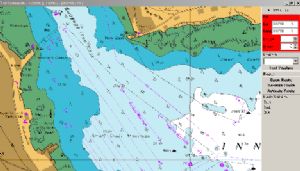
"SeaClear supports most of the marine functions required, but it's a fairly simple and uncomplicated piece of software use. With a GPS connected to the PC, the user's position is plotted centrally on the best chart available. As the boat moves, charts are automatically changed. Routes can be planned across multiple charts at all scales, and waypoints lifted. AIS targets can be plotted with CPA info." Also, you can snag A4 custom chartlets for printing using the screenshot software provided..
When considering power consumption with Windows on board, bear in mind there will probably be long periods of passage time where you're away from dangers, in the middle of nowhere, and don't need the laptop on at all.
"Also remember at all times to keep a plot on an up to date paper chart as well, this is pure common sense, in case of equipment faliure"
Bonus Tide Tables
As a bonus you'll find 400 tide tables embedded into the SeaClear Windows setup. No internet needed, quickly find out HW/LW times at you destination.With a couple of clicks see a whole months tides for the chosen tide station. 400+ locations.
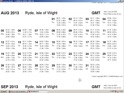
Tide table in SeaClear
- Feature: An embedded set of 2013-June 2014 tide tables for 400 UK/Irish locations showing a full months tables (in familiar format, similar to printed tide tables) for each location. No internet connection, it's built in.
- Benefit: With a couple of clicks from directly within SeaClear, you can choose a tide location and see a display of the whole years monthly tide tables. Scroll up and down to see the month you're interested in, full screen. At sea or at home.
.
Getting a bit technical: Let's see how a real customer has ramped up this system to the max...
" I am on the west coast of Ireland and got the UK/ Irish maps through a website called Visitmyharbour for about 30 euro and they also have a good workthrough on how to install the charts on an android device so as well as the 800 charts on my laptop i also have them on my samsung smartphone and the accuracy is down to a couple of meters.
Now the clever bit.. using a iPad as a cockpit repeater for SeaClear
There is also a small app available called idisplay which I run on both the windows laptop at my nav station and on an ipad in a waterproof case at the helm, idisplay extends the laptop monitor display to the ipad and I can use the ipad to start programs etc on the laptop, have found this system to be really effective. Windows is far more stable now than it ever was and I have no problems with the machine stalling or needing rebooting. Seaclear only needs a very basic laptop to run and the difference in price will surely mean more and more people are installing laptops instead of small screen chartplotters"
This customer has his SeaClear running down below, maybe even with AIS connected. Then he uses uses his iPad in a waterproof case as a cockpit repeater (works with Android tablets too).
The main advantage of doing things this way would be if you had AIS connected to SeaClear and wanted to see the shipping around you while at the helm. If fully intergrating a Windows machine running this package, you can hook up depth and wind instruments, and even use SeaClear to control the Autopilot to keep you on track.
So hopefully you're starting to see just how versatile this system is, and how you could make real use of it all.
SeaClear, although an easy to use navigation program, has hidden depths. Even after years of using it we're finding new features. For those of you prepared to scratch below the surface, we've embedded a whole BOOK, called "SeaClear Unleashed". Written by Richard Fairman BA, the format has been modified to be fully searchable.
You'll be glad you've got this system (esp with a tablet in the cockpit) when you're making your way up an unfamiliar estuary in the dark or fog. When trying to find your mooring in the pitch black. When the weather means a quick change of plan and shallow banks are all around. When a fierce tide is setting your boat somewhere you don't want to go..
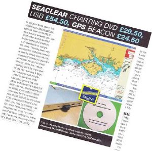
Magazine review:
Charts for SeaClear, and our wireless GPS were fully reviewed and discussed in "Sailing Today" magazine, Feb 2012 issue, pages 43 and 44.
It earned the Sailing Today "Recommended" tag and 4 out of 5 possible stars.
BUY NOW IN STOCK FOR DESPATCH TODAY
"Charts for SeaClear UK/Ireland 2013 Edition". As with all physical products we make and sell..
There is a 30 day no quibble money back guarantee,
Try this at home risk free. Please note a DVD drive is needed to use this package. Use the box below to buy the DVD- You won't get newer charts anywhere.
DVD Price £29.50 plus 1.95/2.95 postage UK/EU. Price in box is the grand total payable
Charts are fully licensed FOR NAVIGATION Logged in full members of VisitMyHarbour go HERE
Other options available, buy on encrypted USB dongle CLICK HERE
The dongle offers all the features of the DVD, inc Tide Tables, up to 4 Android installations, portability, etc. BUT: No DVD drive needed, and ONE FREE CONTENT UPDATE 7-11 months after purchase
For PC/laptop use there is NO difference in speed between the dongle and the DVD, so if your laptop has a DVD drive we recommend the DVD. Don't forget the DVD only spins once when the package is started to verify it... after that you can remove it. (likewise with the dongle)
Questions ? 01983 567866 M-F 10-6 Sat 10-1.30 We're easy to get hold of.
Customer comments:
"I ordered your Seaclear on Monday and it arrived on Tuesday. I installed it on my home laptop yesterday and was most impressed. Today I installed it on the laptop on my boat and could not sort the GPS. A call to you gave me the answer and that is now working.
I have been using N*******r for the last twelve years which has included eight Atlantic crossings and most of the Western seaboard of Europe. I have not been impressed by their service, for which they charged, or by the expense of the charts.
I am extremely impressed by your efficiency so far and staggered by how inexpensive your product is. Whilst I have yet to get to grips with waypoints and routes, I have no doubt that I will be using Seaclear rather than N*******r." MW
"Many thanks for the swift delivery of SeaClear. So far (in the first few days) I have visited several areas with which I am familiar and I have spent a pleasant couple of happy hours going about re-finding my old cruising grounds.
What an inspired product. I don't claim to have mastered all it's little nooks and crannies but I'm looking forward to planning this summers' cruises" R&M
"I'm very impressed with SeaClear on the USB Dongle. I bought it for use on my 20' Hardy Bosun but last night took it to work (I'm a Pilot) with my 7" Asus to try out "in action". Superb, my days of scanning and calibrating are over.
Do you have experience good or otherwise of use with a AIS Pilot Plug (usb) with SeaClear?
Best Regards, and many thanks. Martin."
"I was researching a cockpit repeater option for my boat which has a good GPS at the nav station. There seemed to be some difficulties and costs associated with getting what would amount to a whole new GPS when VMH email popped into my inbox, with the Android capability.
Looking on the VMH site, they recommended the Motorola Xoom. I found a nearly new one on the net at a good price and bought the DVD. Following installation of the Marine Navigator app, and the activation code, it was mostly plain sailing, except that this first PC I tried to use to transfer files would not "see" the tablet on USB socket. Have not yet worked out why. VMH instructions were clear and accurate.
Not yet tried it in anger, but so far I'm very pleased. Its a first class product created by accessible and very helpful people with a real understanding of sailors' needs.
If you could also work out a similar approach to Ordnance Survey mapping, you'd collar another significant market share.
Best wishes, Dave"
Quick summary of the DVD/USB dongle versions:
- Full coverage UK/Irish waters 800+ Chart/lets all PRELOADED
- Charts are licensed "For Navigation"
- All on one Windows compatible DVD/USB dongle
- Portable, install on multiple machines
- DVD acts as "ignition key", spins ONCE on start up, then stops.
- Superfast, average new chart loading time 1 seconds
- GPS compatible Compatible GPS for SeaClear
- AIS compatible Get an AIS receiver to go with SeaClear
- Tried and tested SeaClear navigation software included and set up
- Fully expandable to other areas, Med, US, West Indies etc.
- No updating, just replace package (at discount) to get new charts.
- Free 2013/2014 Tide-Tables
- Android installation ability built in, 4 possible activations.
- 30 day "No Quibble" money back guarantee.
The downside of all normal installed Windows packages is that they are locked to a single machine, thus not portable. Our SeaClear packages can be installed on multiple machines, at home, on board, at work. Our unique system uses the DVD/USB as an "ignition key". It needs to be present to start up our package, but then can even be taken out. Lightning fast too.
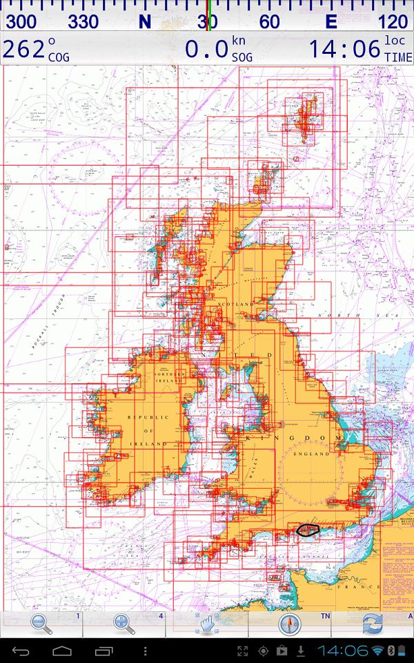
Coverage provided in this package (Windows & Android)
Each chart is represented by a red outline
Other areas and other compatible charts...
This particular DVD covers all the UK and Ireland (inc. Channel Islands) at all scales. For Channel sailors it will get you across, show all shipping lanes, and even allow you to approach French harbours. It covers as far south west as Ushant. You would need French harbour charts for harbour entry.
Other editions available, click titles to find out more::
 Sea Fishing Edition (South Coast and Bristol Channel areas), overlaid with 400,000 spots where roundfish may be sheltering around UNCHARTED seabed obstructions.. click here NO ANDROID or Tide Tables
ALL NEW: 2013 edition covering UK/Ireland/Spain and Portugal... inc Atlantic islands and into the Med as far as Menorca Android capability, no Tide Tables.
Believe it or not, the UKHO are not the only ones producing original surveys and charts in the UK. Some areas of Scotland (where ships are unlikely to venture) are being surveyed specially for intrepid small craft mariners. These charts are made by Antares:
"Antares Charts is a source of 'unofficial' very large scale electronic charts and related pilotage information created by unqualified enthusiasts.
Focusing on the West Coast of Scotland it is aimed at experienced navigators, to supplement information available from more authoritative providers."
Best of all they are inexpensive and will work fine with our "Charts for SeaClear" packages, Android compatible too. Get the best of both worlds, official charts and private locally surveyed extra large scale charts:
http://www.antarescharts.co.uk/
(these will work with Marine Navigator in Android too !)
SeaClear is fully expandable to cover many areas of the world:
 Free charts in BSB format are available for US and Brazilian waters. Google "NOAA" or "DHN Brazil" to find the latest versions of these. We provide versions of SeaClear pre-loaded with many of these charts that are "Ready to use", for VMH members only.
This 2013 package contains an overview chart of Brazil for testing in "My Own Charts" folder.
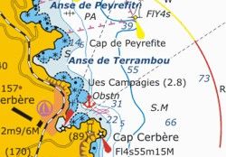
Yachtua, a Ukranian website, have been maunfacturing and offering SeaClear compatible charts for some time now, as downloads in BSB or SeaClear WCI format. They cover most of the Med, inc Turkey and Greece, plus they have West Indies coverage. This seems to fill the gaps nicely between the free BSBs and our own UK offering. Their prices seem reasonable at 3.50 Euros per downloaded chart, and although we haven't tested their charts out, they seem to have a good reputation. We stress they have nothing to do with VisitMyHarbour, we link to them for your benefit...have a look:
Yachtua
http://www.1yachtua.com/
(these will work with Marine Navigator in Android too !)
Questions ? 01983 567866 M-F 10-6 Sat 10-1.30 We're easy to get hold of for advice or tech enquiries
PS:
When you deal up with VisitMyHarbour.com, you are not enriching the coffers of some moneygrubbing PLC. You're not accessing illegal, ripped off, hacked and cracked C-Map charts. You are dealing with genuine hands on boating enthuiasts, who work hard and love the sea. We have a good relationship with the licensors of the chart material (UKHO), and have been using their material for a few years now.
We have worked towards and acheived recognition by Trading Standards, having been awarded the "Buy with Confidence" logo and certificate. Coming from a retail background, we always treat customers as we would like to be treated ourselves and have built up a first class reputation.
Best Regards,


Mackenzie, Bryant and Thomson
• Approved by Trading Standards

 Instead of using a Windows laptop...


 Using the Windows laptop as your on-board chartplotter: If you want to use your Windows laptop as the chartplotter (and can afford the power... they generally draw 2-3 amps at 12v)... Then you can use a GPS to show your position on the charts in SeaClear. Follow your pre-prepared routes. Quickly make adjustments for prevailing weather/tidal conditions. See where you are on the charts at all times. To use SeaClear in this manner you don't need a marine GPS connected, just a cheap compatible USB GPS. We supply a bluetooth GPS kit that's ideal for this at £26.50. AIS with an AIS receiver connected you can see the shipping around you. This is a great safety feature in poor visibility, at night and around shipping lanes. The NASA AIS engine (at about £130) works with SeaClear as do many others.


 Sea Fishing Edition (South Coast and Bristol Channel areas), overlaid with 400,000 spots where roundfish may be sheltering around UNCHARTED seabed obstructions.. click here NO ANDROID or Tide Tables
 Free charts in BSB format are available for US and Brazilian waters. Google "NOAA" or "DHN Brazil" to find the latest versions of these. We provide versions of SeaClear pre-loaded with many of these charts that are "Ready to use", for VMH members only.


